Stream Restoration

Restoring Fairfax City’s Streams

Stormwater management has evolved over time. Development projects, such as subdivisions and shopping centers, were required to meet the standards in place at the time they were built. Newer construction projects must meet greater water quality and quantity control standards than older ones did. Newer methods of slowing and storing stormwater runoff are improving water quality in our streams, but some of our streams are in need of restoration.

Fairfax City is a small, urbanized jurisdiction with limited options for meeting our Chesapeake Bay pollutant reduction requirements. The city’s diversified compliance strategy includes stream restoration, stormwater facility retrofits, outfall restoration, and consideration of additional nutrient credit purchases. Stream restoration provides the most credits and the biggest benefit to local water quality.

Pollutants Negatively Affecting the Chesapeake Bay

Nitrogen, phosphorous, and total suspended solids (TSS, or sediment) are three stream pollutants that have been identified as a measure of water quality for the Chesapeake Bay.

Nitrogen and phosphorous can cause algae blooms. Excessive algae can block sun from reaching aquatic grasses. This can cause the grasses to die and reduce the levels of oxygen in the water, which can then stress or kill fish and other aquatic organisms. Sediment suspended in the water can harm fish and other aquatic life directly. It is like trying to breathe in a dust storm.

Environmental improvement projects, such as stream restorations, are designed to reduce the amount of pollutants that reach the Chesapeake Bay.

Visit the links below for additional information and frequently asked questions about stream restorations.

How does stream restoration reduce pollutants in the water?

There are three ways that stream restoration projects help reduce these pollutants.

Reducing erosion directly reduces the amount of sediment (TSS) that is carried downstream. Phosphorous and nitrogen are bound to sediment, so by reducing sediment we reduce all three pollutants of concern. One of the goals of stream restoration is to reshape the stream channel to make it more resistant to erosion.

Eroded banks are unstable and are susceptible to continued erosion during strong storm events. Erosion can cause stream channels to shift, often impacting private properties and utilities near the stream corridor.

The second is by improving the environment in and around the stream to better act as a stormwater filter. Healthy vegetation on the streambanks and the buffer area on both sides of the stream help filter pollutants from runoff before it gets to the stream. Healthy vegetation also promotes infiltration of water into the ground. A wider stream channel provides a larger area for stream water to exchange nutrients with the surrounding soils (the hyporheic zone).

The Resource Protection Area (RPA) is a 100ft buffer on each side of a stream. A healthy RPA filters pollutants from stormwater and allows stormwater to infiltrate before it reaches the stream. Stormwater that infiltrates in and around the streambed exchanges nutrients with the surrounding soils and improves water quality.

A third way that stream restoration reduces pollutants that are transported downstream is by promoting floodplain connectivity. Floodplain connectivity is where a stream corridor is reshaped so that waters can spread across a wider area. Waters flowing across a wide area tend to flow more slowly, and sediment can deposit from slow-moving waters more easily. Over time, this sediment trapping process can create pooling areas that establish wetlands which further promote the exchange of nutrients with the surrounding soils.

How do we know that stream restoration works?

The Virginia Department of Environmental Quality and the Department of Conservation & Recreation have adopted methods that have been vetted and approved by the Chesapeake Bay Program’s Urban Stormwater Workgroup to calculate the amount of nutrients a project is credited for removing. These methods are accepted by the U.S. Environmental Protection Agency.

Every locality in Virginia in the Chesapeake Bay watershed evaluates the effectiveness of environmental projects using these calculation methods. One of the primary inputs in these calculations is an analysis of soils from the project site to determine how much phosphorous and nitrogen is tied to the sediment. This was done for the design of the Stafford Drive stream restoration project to meet design requirements for stream restoration projects in Virginia.


Soil samples are taken at each stream restoration project site and analyzed so that the amount of nutrients the project would prevent from flowing downstream can be estimated.

Stormwater management is a constantly evolving science and the approaches to calculating nutrient reductions have and will change over time, generally trending toward being more stringent and precise.

Locally, we can look at recently restored stream segments to see how they are holding up. Stream restoration areas are inspected and maintained by the city each year. The segment of Daniels Run behind Daniels Run Elementary School on Blenheim Boulevard was restored in 2016. It has developed healthy stands of vegetation along the banks and the stream channel has proven to be resistant to erosion. This segment has required minimal maintenance.


These are photos taken in July 2023 that show the stream segment behind Daniels Run Elementary that was restored in 2016. Trees and shrubs have matured into a healthy Resource Protection Area. Erosion is being controlled and this segment requires limited ongoing maintenance.

Tusico Branch flows behind several residential private properties between Keith Avenue and Chain Bridge Road. This segment was restored in two phases in 2020 and 2021. This area has also proven to be resistant to erosion and regular maintenance is mainly focused on bamboo control.

Why are large stones placed in streams if Natural Channel Design principles are being followed?

Natural Channel Design is the practice of designing stream restoration projects to mimic the stable conditions of a natural stream. These calculated conditions are one of several variables that are considered. Other considerations include the location of buildings and utilities, floodplain limits, and existing stormwater outfalls to the stream. Natural channel design principles are followed and impacts to trees and properties are minimized to the extent possible.

There are some areas where natural solutions will not work to control erosion. These can include stormwater pipe and culvert outfalls where large volumes of water enter the stream at higher velocities. It can also include areas where stream flows meet sharp bends in the stream bank. Areas like these must be highly resistant to erosion, and in many cases, vegetation is not sufficient and riprap (stone) is the best option to control erosion.


Areas like this culvert outfall on Fair Woods Parkway must handle large volumes of water and high energies during strong storms. Non-erodible materials like stone are needed in these areas to control erosion. The photo on the left was during construction, and the photo on the right is after construction. The outfall side of this culvert is the beginning of the 2,400 linear foot Stafford Drive stream restoration project.

Can streams be restored without removing trees?

The scale of the stream restoration project, and the resulting tree removal, is dictated by the physical attributes of the existing stream and constraints of the project area. Streams that are deeply incised or stream corridors that have filled with sediment over time will often require a wider area to construct the restoration.

All streams have floodplains around them. The floodplain represents the predicted extents of flooding during a 100-year storm event, which is a storm intensity that has a 1% chance of occurring in a year. While it may be possible to restore a stream by filling the streambed instead of lowering the floodplain, doing so can expand the floodplain and create potential flood impacts to surrounding properties. Restoring a stream without expanding the floodplain often requires widening the stream channel and/or lowering the stream corridor elevation.


This map shows properties near a stream (blue line) in the floodplain (red area). Minimizing impacts to private properties and avoiding increases to flood risk must be considered along with impacts to trees and numerous other factors in the design of a stream restoration project.

If an actively eroding stream is left alone, the trees along the banks will be lost as the stream banks shift due to erosion over time. Tree roots help hold sediment in place. Trees that uproot along the bank allow significant amounts of sediment to wash downstream. Uprooted trees also expose new stream bank surfaces to flows. These areas will continue to erode and allow more sediment to wash downstream.


These photos are an example of tree loss that is occurring along the Stafford Drive stream restoration project corridor due to bank erosion. Significant amounts of sediment can be released when trees are uprooted. This also allows for further erosion to occur since the tree’s root systems are not present to anchor the earthen stream bank material.

The goal of stream restoration is to accelerate the natural process of bank erosion to a stable condition without allowing all the sediment to flow downstream.


Streams in need of restoration are often in Stage 2 and 3 and will continue to erode until they are stable (Stage 5). The goal of stream restoration is to reconstruct a stream corridor to a stable condition without waiting for the natural erosion process to occur.

Are there alternatives to stream restoration?

The city is a small, urbanized jurisdiction which limits the options available to meet our Chesapeake Bay pollutant reduction requirements. There are alternatives to stream restoration that can generate pollutant reductions, but not at the scale necessary to meet requirements on their own. The city is on track to meet requirements for phosphorous and sediment reductions. Nitrogen is a remaining requirement.

Stormwater management facility retrofits are a part of the city’s compliance strategy, but we don’t have enough facilities to retrofit and these projects don’t generate enough credits to meet Chesapeake Bay requirements on their own.

As an example, the retrofit of the detention pond at City Hall receives drainage from 3.5 acres and generated 7.4lbs of nitrogen credit. The Stafford Drive stream restoration project area receives drainage from 2,425 acres and would generate 323lbs of nitrogen credit. The city’s remaining reduction requirements to meet the Chesapeake Bay requirements by the due date in 2028 are 2,625lbs of nitrogen, equivalent to the credit from 354 City Hall pond retrofits.


Small environmentally positive projects like the retrofit of the stormwater management pond across from City Hall help improve our stormwater infrastructure, improve local water quality, and provide small amounts of credit toward our pollutant reduction requirements. This project was completed in 2023.

Another alternative is to purchase nutrient credits. Nutrient credits are generated by constructing environmental projects outside of the city but within the Chesapeake Bay watershed. These credits can be purchased and applied toward regulatory requirements. The city has purchased a small number of nutrient credits (81lbs nitrogen) at a highly competitive cost, made possible through state grant funding. The downside to credit purchases is that there is no tangible local improvement and no localized improvement to water quality. Credit costs have been increasing with demand and credit purchases are generally not as cost effective as a local project. With many stream segments and outfalls in need of restoration, concentrating most of the funding to local infrastructure improvements provides the most benefit to the community.

The city has a diversified compliance strategy that includes stream restoration, stormwater facility retrofits, outfall restoration, and consideration of additional credit purchases. Of these, stream restoration is the approach that would provide most of the credits necessary to achieve compliance and the most benefit to local water quality.

Is urban development responsible for the degraded stream conditions?

Urban development is one of several factors that contribute to stream corridor impacts. Development projects have had to meet stormwater management standards in place at the time that they were built. These standards are intended to mitigate the impacts of development, and those requirements have increased over time. Developments in the city, regardless of their age, meet the stormwater management requirements of their time, and newer developments must meet greater water quality and quantity control standards than older ones did.


The evolution of stormwater management requirements is like how automobile emission standards and the equipment that is installed in new vehicles to meet them have evolved over time. 

Other factors that contribute to stream corridor impacts are increased frequency of intense storm events, salt application for snow/ice control, behavioral impacts (litter, illicit discharges and dumping, pet waste, fertilizer use), construction activities, and agriculture. While we may not have many agricultural activities in the City of Fairfax, there are agricultural areas elsewhere within the Chesapeake Bay watershed.

What is the city doing to manage the impacts of development?

In the planning phase, the city ensures that developments meet statewide standards for stormwater management. This includes controlling runoff and improving water quality. Detailed calculations quantify the impacts of the development as well as the mitigation provided by proposed stormwater management facilities. Erosion & sediment control plans are reviewed, and these plans show how sediment and runoff from the construction activity are prevented from affecting downstream areas.

The city conducts inspections in the construction phase to ensure that plans are being followed. In addition, the city ensures that statewide requirements to develop and implement a Stormwater Pollution Prevention Plan (SWPPP) are followed. The SWPPP covers good housekeeping practices, erosion & sediment control, and emergency spill response.


Public Works inspectors ensure that construction activities follow standards for erosion & sediment control and stormwater pollution prevention.

After construction is complete, all stormwater management facilities undergo a final inspection to confirm that they were constructed per approved plans and that they are functioning properly. Public and private stormwater management facilities in the city are inspected annually. Private property owners are responsible for the maintenance of their stormwater management facilities and the city coordinates with each owner when maintenance becomes necessary.

The city is also developing a green building policy which will encourage the use of green infrastructure and low impact development practices. These practices have several benefits that include reducing runoff, better stormwater management, and use of pervious and vegetated surfaces.

Won’t the stream eventually go back into disrepair if it is restored?

Stream restoration is like other types of constructed infrastructure in that it will require periodic maintenance to continue to function as it was designed. Current stream restoration projects (Daniels Run, Tusico Branch Phase I & II) are in the city’s inventory of stormwater management facilities and are inspected each year. Maintenance needs such as invasive species removal and erosion repairs are also completed each year based on the results of the inspection.

The city’s completed and upcoming stream restoration projects have been partially funded by Virginia DEQ Stormwater Local Assistance Fund (SLAF) grants. One of the requirements of a SLAF grant is to develop and implement a maintenance & monitoring plan for the funded project to ensure that the project provides long term benefits.

The city must obtain permits from U.S. Army Corps of Engineers (USACE) for most stream restoration projects. Part of the permit requirement is to provide a vegetation monitoring plan to ensure the proposed plantings establish in the project area. Monitoring reports are submitted to DEQ and if successful planting criteria are not met, additional monitoring will be required until all criteria are met.

Tusico stream
This photo was taken in Spring 2022 in the Tusico Branch Phase 2 project area. Public Works inspects stream restoration project areas annually and performs maintenance as needed. This is partly because it is a requirement of the permits and grant funding that was used to build these projects, but mainly because monitoring and maintenance is good practice for these public investments.

What can I expect during a stream restoration construction project?

We can use photos from Tusico Branch stream restoration project to help illustrate the construction process.


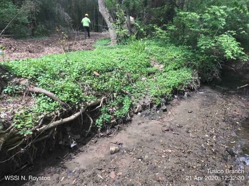
Eroded stream bank, at Tusico Branch Phase 1 project, April 2020

Stream restoration requires the use of heavy equipment and land disturbance. The initial stages of the project are usually the most disruptive. Crews must gain access to the site to install erosion & sediment controls, which is the first step in the project. This often requires creating an access path to and clearing of brush and trees along the perimeter of the project area.

After erosion & sediment controls are installed, crews will begin clearing existing trees and vegetation from the area to be worked. At this stage, the project team will often be able to make adjustments to the tree removal plan in the field to save as many trees as possible. Adjusting access paths and using different types of equipment can save trees.

These first parts of the project will generate noise from excavators, chainsaws, and trucks.


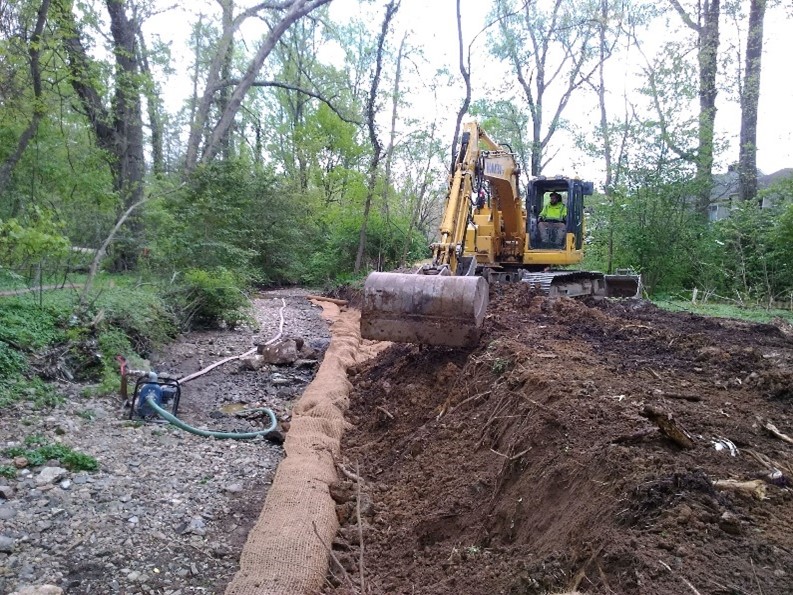
Tree removal complete, stream pump around in place, and reshaping of the stream bank in progress.

After the work area is cleared, crews will begin reshaping the streambanks, installing features like step pools and log sills, and installing stone where needed. Work in the streambed requires the existing stream to be temporarily diverted or pumped around the project area. Crews must be careful not to allow the stream to carry away loose sediment from the construction activities. This part of the project typically generates less noise than the initial stages but still does require the use of excavators and other heavy equipment. Truck traffic will bring materials in and haul debris out of the project area regularly


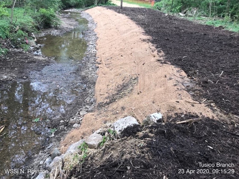
Continued reshaping of the stream bank and installation of a coir roll (natural fiber roll) on the new bank, and soil stabilization matting.

After the stream has been reshaped and water control features are installed, the next step is stabilization. This is where live stakes, shrubs, trees, and seed mixes are planted. Fiber matting will often be used to help keep small plantings in place until they can establish into the new soils. This is the least disruptive part of the project and much of the landscaping work is done by hand. Depending on the time of year, tree and shrub installation may be postponed for favorable weather in the spring and fall planting seasons.


Streambank immediately after construction has been completed. Topsoil and seed have been placed.

The last step occurs after the site has been stabilized, which can be several weeks after planting. At this stage the crews can remove erosion & sediment controls and pull out of the project area. You may see crews and equipment come back to the site a few more times to make final corrections.


Streambank in July 2020, just 4 months after construction started. Grass has established.

Larger stream restoration projects can involve going through these steps in smaller sections of the project and then moving to the next area. Stream restoration generally starts on the upstream end and works toward the downstream end.

All work is done within the limits of the city’s noise ordinance, though work hours are generally shorter and occur Monday through Friday from 7 a.m. to 4 p.m. Public Works provides specific information about project impacts to nearby residents before work starts. This information is also posted on the project website.

During and right after a stream restoration project, the area will look like a construction site. The project is not yet complete, even though you may not see people working! Planting can take several weeks to establish. The appearance and amount of vegetation will improve substantially by the following growing season. You may see crews come back out to reseed and replace plantings. Once

The site will continue to repair itself over the next several months and after two years it can be difficult to tell that work was done there at all other than by looking for stone structures, log sills, and similar constructed stream features.

Additional Questions?

Email pw-stormwater@fairfaxva.gov to contact City Staff with general questions or comments about Stream Restoration projects.